Waterworks by Stanley Greenberg: A Rare Photographic Journey Into NYC’s Underground Infrastructure
Welcome to this edition of [book spotlight]. Today, we uncover the layers of 'WATERWORKS: The Hidden Water System of New York,' by Stanley Greenberg (published by Kris Graves Projects). We'd love to read your comments below about these insights and ideas behind the artist's work.
There’s an entire city beneath New York, and Stanley Greenberg photographed it.
For years, he searched for the hidden infrastructure that keeps the city alive: tunnels, shafts, gatehouses, and pipes buried far below the surface. He spent decades getting rare access, cataloging forgotten sites, and building a detailed visual record of New York’s massive water system. The result is Waterworks, a book that documents the city’s underground in a way few people have ever seen. If you’ve ever wondered how a place like New York really works, this book has some surprising answers.
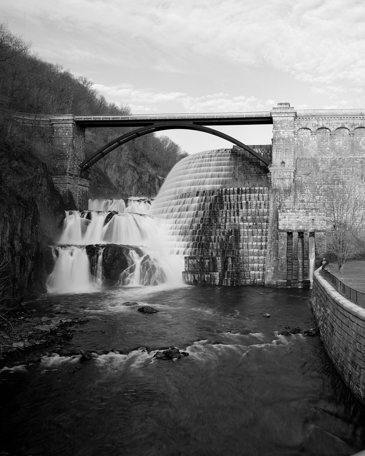
Waterworks documents the hidden systems that keep New York City running, from tunnels deep underground to strange structures hidden in plain sight.
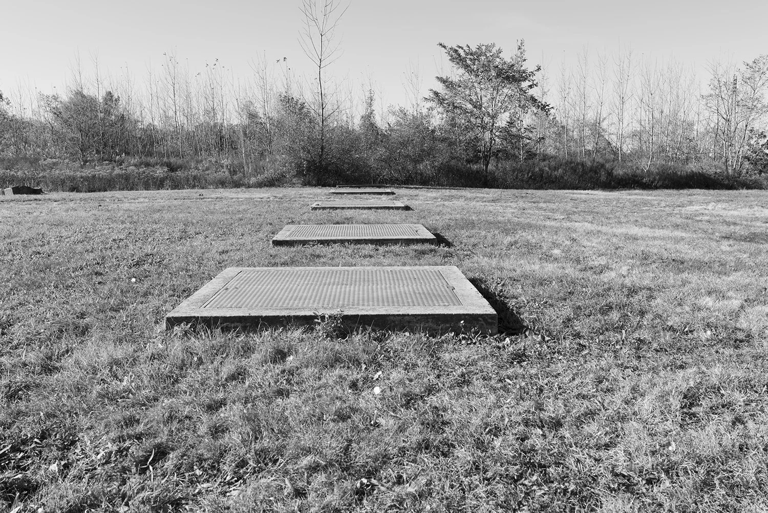
The photographs are the result of years of research, limited access to restricted sites, and a focus on small details most people overlook. Greenberg draws attention to the infrastructure that surrounds us but often goes unnoticed, such as ventilation shafts, valve chambers, and forgotten gatehouses. His images reflect both the scale of the system and the political choices behind it, asking who built it, who benefits, and who was displaced. Together, the book becomes a portrait of a city shaped as much by what lies below as by what stands above.
This is not your typical New York City photo book.
About the Book
Waterworks by Stanley Greenberg is a long-term photographic study of New York City’s vast and often invisible water infrastructure. First published in 2003 and reissued by Kris Graves Projects, the book reveals tunnels, aqueducts, shafts, and hidden structures that most New Yorkers pass every day without realizing their function. Blending large-format photography with extensive research, Greenberg traces the physical system that delivers water to the city while raising questions about access, power, and public space. The book includes rare images made before 9/11, when access to critical infrastructure was more open, as well as a fold-out map and updated information reflecting two decades of continued exploration. (Kris Graves Projects)
Overview of the project: What inspired you to begin photographing New York City’s hidden water infrastructure, and how did the project evolve over time?
I’ve always been interested in how the city worked. After graduate school I had several jobs in New York City government in the 1980s. At one of them I was taken to see a construction site 300 feet underground that felt like a science fiction movie. (It was part of the city’s new Water Tunnel No. 3, now finally nearing completion.) In my six years at several agencies and the Mayor’s office I learned a lot about how the city worked. After I left my city job in 1988 I started thinking about all the places that people have heard of but don’t get to see, like the insides of bridges, tunnels, power plants and the water system. I started calling and writing letters and was able to get access to photograph many of the sites. It took six years to get into all the places I wanted to see, and Invisible New York was published in 1998 by Johns Hopkins University Press. It included several sites from the water supply, and I realized that the system was so big and complex that I wanted to do another book just about the water system.
I also spent some time working with people from Cooper Union to organize the Department of Environmental Protection’s (DEP) archives; I cataloged over 10,000 photographs and had access to all the original drawings dating back to 1840. So I had a pretty good idea of what was in the system. It was very difficult to get permission to photograph but I was eventually (long story) given almost complete access. I finished photographing in Spring 2001, and after 9/11 all access was closed. Waterworks was published in 2003, but only after the city agency tried to stop me from releasing the book. A few months later they purchased 200 copies.
Afterwards I worked on other long-term book projects which were mostly away from New York. But I often thought about the parts of the water system I had missed. The list of those sites got longer and longer and gradually I started photographing them again. But this time I had no special access. I would have liked to have visited a few of the sites I hadn’t included in the first book, but I became more interested in the hundreds of components of the system that were right on the street. All through this time I was also studying and photographing other infrastructure systems in the city, things like electrical tunnels and the natural gas system. I began to assemble a map of sites as I came across other parts of the water system (unmarked buildings, shaft entrances, pumping stations, etc.) I spent most of my time doing research and then went out to try to find the sites. It became a different kind of project; more of a conceptual hunt for the places they didn’t want me to discover. Larry Buchanan, who has worked on some great projects at the New York Times, designed a separate map that comes with the book. There’s also a Google map that I created that’s now public; it’s been viewed over 12,000 times in the first two months since it was made available, so there’s clearly interest in how the system works. I’ve also started to install markers and signage at some of the sites around the city; pictures and text explaining what the odd-looking object in front of you that you may not have even noticed is for.
Historical context: How did understanding the history of New York’s water system influence your photographic narrative?
Most of my projects come from curiosity about the history of a place or a system, or political analysis, or often both. I’m interested in the way decisions are made about land use, placements, and public space. What are the places, structures and mechanisms that allow the water to flow (or the gas or the electricity). And I also want to get people to think about why and how it got there. Who built it, who profited, who lost their homes, who was harmed? I don’t spell it all out in most of the projects but hopefully you will start to think about it once you’ve seen the pictures. Some of my other projects include much more explanation (manufactured gas facilities, Springs and Wells of Manhattan and the Bronx, Dutch Houses in Brooklyn.) Text has become more important in my recent projects.”

Technical considerations: What equipment and techniques did you use to photograph in the varied and often difficult conditions of the water infrastructure?
The earlier pictures were all done with a 4x5 view camera; later pictures were done with several different digital cameras. View cameras don’t lend themselves to ten-mile walks, so I had to find something smaller that I could carry all day long sometimes on my bicycle. And it’s a lot easier to photograph through a fence or a hole in the wall with a hand-held camera with a small lens. A few of the later photographs of larger structures were done with a medium format digital camera, which is what I use for most of my work now. One gatehouse had a loose door that opened up two inches. I was able to slide a phone camera in and get a picture. I miss the view camera, but I don’t miss carrying all the equipment or breathing the fumes in the darkroom. The view camera slows you down, in a good way, so you’re very careful about your compositions. I often still work that way with the digital cameras.
For another book project (CODEX New York, Monacelli Press) I walked every block of Manhattan. Afterwards I wanted to do other long walks across the city, and researched the three water distribution tunnels as well as the earlier aqueducts. I walked them all, and found the shaft entrances along the route of each tunnel. For those parts of the project I felt more like I was making a catalog. I made multiple views, especially since there was always foot and car traffic nearby, and selected what I liked later.

Advice for photographers exploring hidden systems: What advice would you give to photographers interested in documenting hidden or inaccessible systems within urban environments?
The only advice I will offer is do your homework.
Balancing aesthetics and documentation: How did you balance creating visually compelling images with the goal of documenting the technical aspects of the water system?
There’s always the pressure (desire?) to make a great picture, but conceptual and book projects have different requirements. Working in the tunnels and with large structures makes you want to create images that convey the monumentality of the structures. But the little parts, which are just as important, lend themselves more to a catalog or typology approach. It’s also interesting to me to make a picture of something that looks like nothing. Some explanation may be needed. The titles of the photographs tell you what the object is, but I don’t go into a lot of detail in the book. I’ve been thinking more about leading walks around the city to point out all the bits of infrastructure. You might see a metal plate in the sidewalk and wonder if it’s an entrance to a tunnel 1000 feet below, or to an underground sewer pumping station. The trick is recognizing which is which.


Impact of the project: What do you hope viewers take away from Waterworks, and has the project influenced public awareness or policy regarding New York’s water infrastructure?
People will take what they want from the pictures. I’d like to give them some visual literacy about the city’s infrastructure. Hopefully they will also consider that this is one of the many things that government does, and that taxes pay for. The water system didn’t just happen; lots of money was spent, lives and homes were sacrificed, decisions about who would be harmed were made, and some people made a lot of money.
The fold-out map in the book was very important to include, along with the Google map that I’ve been making and using for many years. The official DEP map doesn’t really show anything besides the reservoirs and the general location of the aqueducts and tunnels. I want people to be able to see what’s right in their neighborhood, or visit whenever they’re traveling. I finally made the Google map public and it’s had over 10,000 views in just a few weeks, so I think people are interested in the subject.
Future projects: Are there other hidden systems or infrastructures you’re interested in exploring through photography in the future?
I’m interested in all kinds of infrastructure but I’m not sure what the next book is. I’ve made a few trips to other cities to photograph water systems, so there may be another publication in the future. I’ve done research for several other projects, and I have maps of where I want to go, but it doesn’t seem like a great time to travel right now. I’m also working on a project about scientific ephemera still in the early stages.
To discover more about this intriguing body of work and how you can acquire your own copy, you can find and purchase the book here. (Kris Graves Projects )
More photography books?


We'd love to read your comments below, sharing your thoughts and insights on the artist's work. Looking forward to welcoming you back for our next [book spotlight]. See you then!